
-Edited by Bev Mortimer- Heavy rainfall, very cold conditions, rough seas, heavy snow, and gale-force winds this weekend – and NSRI issues safety warning – see below…
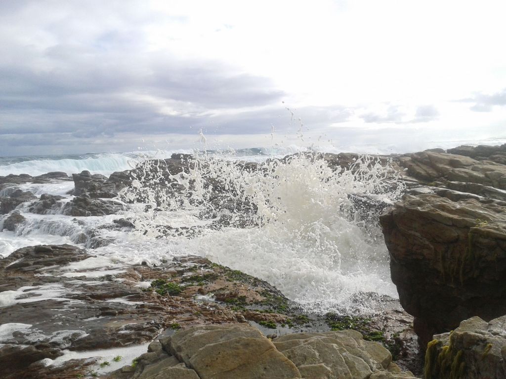
Photo by Bev Mortimer
The SA Weather bureau this morning said a strong cold front and cut-off low is expected to affect the Cape provinces this weekend, 28-30 July .
“Heavy rainfall, very cold conditions, rough seas, snow, and strong to gale force winds are expected over parts of the Cape provinces this weekend as a strong cold front makes landfall on this evening, 28 July along the west coast of the country.
Tomorrow, Saturday, a cut-off low rapidly develops over the Western Cape further exacerbating weather conditions. “Although the Cape provinces will experience the brunt of these conditions, the central and eastern parts of the country will also experience cold to very cold conditions from Saturday evening into Sunday.
“A strong cold front is expected to make landfall along the west coast of South Africa and Namibia this evening, causing scattered to widespread showers and rain along the coast of the Northern Cape and the western parts of the Western Cape. Very rough sea conditions along the along the coastal areas and windy conditions over the central and western interior of the country are also anticipated.
“On Saturday, a cut-off low (an extension of a deep low-pressure from the main westerly wave) develops over the Western Cape and is expected to spread to the south-western parts of the Eastern Cape during Saturday afternoon. Cut-off low pressure systems are well known for causing flooding, gale force winds and snowfall in winter.
“Widespread rainfall can be expected over the western and southern parts of the Northern Cape, most parts of the Western Cape, and parts of the Eastern Cape on Saturday. Heavy rainfall leading to flooding is possible over parts of the Cape Metropole, Cape Winelands, and especially the Overberg and Garden Route Districts of the Western Cape mainly on Saturday but already over the Cape Metropole from Friday evening. These conditions are expected to spread along the south coast of the Eastern Cape on Saturday afternoon.’
Rough, high seas, strong winds…
“Very rough seas and strong winds with wave heights between 4 -6 m can be expected along the west coast from Friday night, spreading along the south coast of the Western Cape tomorrow and to the Eastern Cape coast tomorrow night, reaching the KwaZulu-Natal coast on Sunday.
“These conditions may cause disruption to beachfront activities and difficulty in navigation at sea for small to medium vessels.
“High seas with wave heights between 6-7 m can also be expected along the south coast of the Western Cape from tomorrow afternoon into Sunday, spreading to the Eastern Cape coast on Sunday which can lead to possible beach erosion and put small to medium vessels at risk of taking on water or capsizing.
Snow..
“Snowfall is expected across interior mountain ranges of the Western Cape, the western and southern high ground of the Northern Cape and the high ground of the Eastern Cape from tomorrow into Sunday and may extend into the Drakensberg region of KwaZulu-Natal and the extreme southern parts of the Free State on Sunday.
“Disruptive snowfall can be expected over the interior high ground of the Western Cape, the northern and central high ground of the Eastern Cape and the southern high ground of the Northern Cape on Saturday into Sunday, which may lead to loss of livestock, closure of mountain passes and result in some communities to be temporarily inaccessible.
Very cold conditions…
“Very cold conditions (maximum temperatures between 5-10°C are expected over the interior of
the Cape provinces from Saturday into Sunday while cold conditions are expected to spread to the central and eastern parts of the country mainly on Sunday
The weather systems are expected to weaken on Sunday while exiting over the south-eastern parts of the country, causing weather to improve mainly from Sunday evening into Monday. But heavy ocean swell will continue to impact the southern and south-eastern coastline on Monday
due to another cold front slipping along the southern coastal areas.
The South African Weather Service is closely monitoring this weather system and will update the public when needed. St Francis Chronicle will provide updates as it receives them.
NSRI warnings…
The NSRI has this morning issued a weather and safety warning for coastal dwellers and visitors tomorrow and this weekend.
Initial spokesperson for the NSRI, Craig Lambinion, said the NSRI appeals to residents and visitors in the southern and western areas of the country this weekend to be cautious as bad weather could impact could impact coastline and inland waterways tomorrow, Saturday..
“We are repeating to shoreline anglers, boaters, commercial seafarers and coastal hikers to be aware of rough sea conditions and the impact of forecasts weather affecting the coastline. “Inland boaters and commercial seafarers should not launch in adverse weather conditions unless absolutely necessary and wear life jackets when your vessel is underway or during commercial operations at sea
“Also paddlers, sail boarders, and people on the beach should be cautious of rough seas strong winds and stronger currents during adverse weather and affected sea conditions, and should be aware of the daily to high tides and low tides, and be cautious along the shoreline, and prepare accordingly without taking risks, the NSRI warns.
“Do not attempt to cross through rivers and roadways affected by flooding or cross over bridges swamped by floodwaters. We are appealing to the public to monitor the southern Weather Service weather updates and the predicted impact.
“Emergency services are on high alert to respond to emergencies around the coastline and assist with flooding an inland waterways.“
